Expert advice from lead guide Mentor Vokshi on the most dangerous section of the Peaks of the Balkans trail
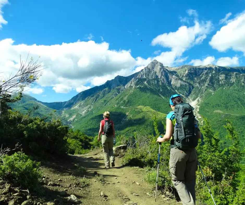
The Valbona to Theth hike is the most iconic stage of the Peaks of the Balkans trail in Albania. Most hikers complete it in summer without incident — a long, beautiful day crossing Valbona Pass with views across the Albanian Alps.
But there is one section of this hike that changes completely when it is covered in snow. It is not the highest point. It is not the longest section. It is the descent from Valbona Pass toward the valley — and it is the only place on the entire Peaks of the Balkans trail where a fatal accident has occurred.
If you are planning the Theth to Valbona hike (or Valbona to Theth) in May, June, or after a late-season snowfall, this guide may be the most important thing you read before you go.
Before we get to the winter routes, here is what you need to know about this stage:
The hike is doable in both directions. Many hikers do Theth to Valbona instead — the ascent out of Theth is steep but the descent to Valbona is gentler in summer. In winter conditions, the direction of travel matters less than knowing which trail to take at the pass.
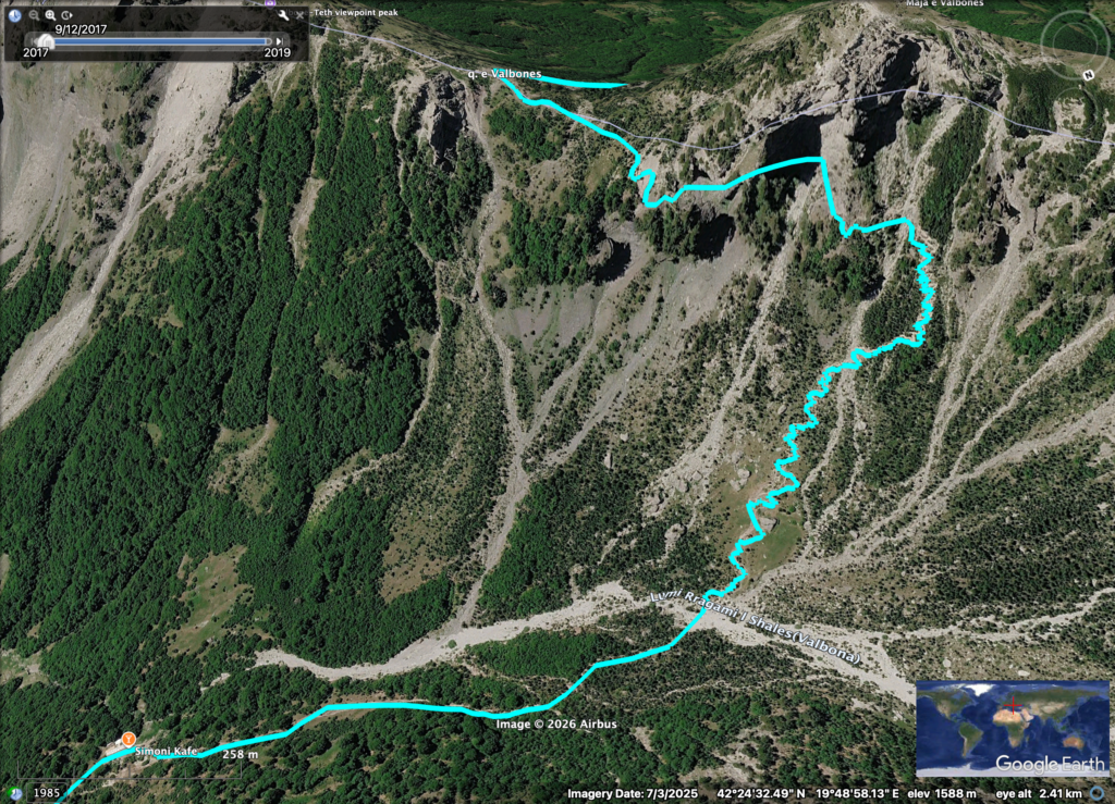
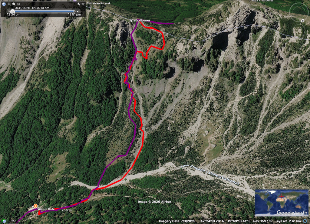
Every hiking app — Komoot, Wikiloc, Maps.me — shows the same route. In summer, it is the correct one: a traverse heading north-northwest from the pass, down through switchbacks, across a longer horizontal section, and then to the valley meadow near Simoni Café at the bottom.
The problem is the first section of that descent. When it is covered in snow, this traverse becomes a steep, icy face with an angle that is extremely difficult to control if you slip. Without crampons or an ice axe, a fall here is very hard to arrest.
This is where accidents have happened. This is where the only fatal accident on the Peaks of the Balkans trail occurred.
We sat down with Mentor Vokshi, one of the most experienced guides on the Valbona Theth hike, to map out exactly what to do depending on the conditions you find at the pass. Below is what he explained — matched to GPS trails on Google Earth.
When to use: The pass and the face below are clear of snow. Typically mid-July through October.
This is the trail shown on all mapping apps. It leaves the pass heading north-northwest, follows a slightly inclined traverse, drops through switchbacks under a large rock, crosses a long horizontal section, and descends to the valley near Simoni Café.
In dry conditions, it is safe and well-marked. In snow and ice — particularly on that initial traverse — it becomes genuinely dangerous. The slope angle means a slip without the right gear is very difficult to stop.
Do not use this trail if there is significant snow on the face below the pass.
Valbona face usual summer trail
When to use: The entire area is under heavy snow, including the saddle itself. Typically April through mid-May, and after major late-season snowfall.
When the summer trail is buried, experienced guides take a completely different line. This route leaves the pass heading roughly northeast and descends directly through a steep, narrow gully — straight down to the flat section at the bottom of the mountain, bypassing the dangerous traversing section entirely.
“This trail requires a lot of experience with snow and ice. You need, at minimum, an ice axe. Crampons would be even better. And B1 boots as a minimum — B2 if you have them.” — Mentor Vokshi
The gully is steep. On a guided Valbona to Theth hike, the guide uses an ice axe to cut steps into the snow so clients can place their feet safely. This is not a comfort — it is a genuine safety advantage.
As snow begins to melt, exposed rock in the upper gully creates a rockfall risk. That is when the third trail becomes the right choice.
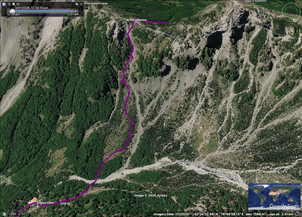
Theth Valbona Winter trail, a lot of snow
When to use: Snow is present but melting — typically late May into June. The upper gully of the winter route is now partially clear and exposed to small stone falls.
This is the most nuanced of the three. It starts on the summer trail from the pass and diverges at a clearly marked split point — there is a signpost on a small pine tree — where the trail turns right. From there it descends through a low-angle meadow (usually still snow-covered, but without the steep exposure), and then rejoins the winter gully route lower down, following it the rest of the way to the valley.
This is the safest of the winter options, but it still requires care. Even soft snow on the meadow section can be slippery without proper footwear.
Theth Valbona Winter trail, melting snow
Mentor was direct:
“Don’t underestimate the whole thing. The minimum for self-guided hikers in winter conditions is an ice axe. Without it, you are putting your life in danger. Crampons are better. B2 boots are better. The more prepared you are, the safer you are.”
Minimum gear for winter or spring conditions:
If you do not have winter mountaineering experience or cannot assess snow conditions yourself, the honest advice is: hire a local guide for this stage. The rest of the Peaks of the Balkans trail you may be perfectly capable of doing alone. The Valbona Pass descent in spring conditions is a different situation.
Mentor made one point clearly:
“You can never fully tell people what they can do and what they should do. Self-evaluation is the most important thing. We can give advice, we can show the map, we can provide the GPS. But if they don’t feel safe, they should contact the company or a guide.”
Ask yourself before you set off:
If the answer to any of these is no, and you are hiking in May or early June, talk to us before you go. We can tell you current conditions on the pass and advise on the right trail.
BNA runs the full Peaks of the Balkans as both guided and self-guided tours. Every self-guided client receives a pre-departure briefing covering current trail conditions, including the Valbona Pass descent. Our guides have led this section in every condition imaginable — early April full snow to late June melt.
10 Days Peaks of the Balkans — Self-Guided 10 Days Peaks of the Balkans — Guided
Questions about timing or conditions? Email us at info@bnadventure.com — we check conditions on the trail throughout the season and will give you an honest answer.
This article is based on a Peaks of the Balkans Podcast episode recorded with Mentor Vokshi, lead guide, April 2026. Listen to the full episode here →.
The GPS tracks for all three trails shown in this article are available to download below. The maps were produced using Google Earth and plotted by Mentor Vokshi based on his direct experience guiding this section.
Join our groups in this spectacular hike in the accursed mountains. Best guide to guest ratio, smaller groups, fast and reliable office support, in depth local knowledge.
Book Now – € 980
10 hiking days, self-guided, across the breathtaking Peaks of the Balkans, a journey that will take you through three countries: Albania, Kosovo, and Montenegro.
Book Now – €810
This is a week-long, 6-day guided trip in the Peaks of the Balkans. The itinerary has been carefully adjusted to include the best parts of the trip itself, comfortably planned.
Book Now – € 765

Balkan Natural Aventure is leading tour oprator in the region. We were featured to major newspapers and hold a partner status with travelife certifier.
Links
Destinations
Locations
Balkan Natural Adventure Sh.P.K
Edit Durham, nr 7
30000 Peje, Republic of Kosovo
Balkan Natural Adventure Albania
Rr. Milto Tutulani nr 26/8
1010 Tirana, Albania